The ASA 105 Coastal Navigation certification provides instruction on navigating using paper-based nautical charts.
Many people consider the traditional paper-based navigation techniques to be outdated in the age of GPS and electronic navigation systems. But it still stands that the electronics may break down at some point, leaving you with only paper navigation to fall back on.
As part of Boston-based Community Boating’s Coastal Piloting course, I learned many of these nautical chart navigation techniques back in 2000…but even back then I only partially absorbed the material, and by now I had forgotten 99.9% of what was taught back then.
So for this Coastal Navigation course, I was going to make sure that I not only learned and mastered each technique and skill, but also that I would take the time to document what I learned – this way if I look forward 10-15 years, I would be able to refer back to my notes and remember or re-teach myself the skills without too much trouble.
The course was at Bay Area Sailing School, and is a 2-day classroom course.
The instructor of the course developed a method of teaching which did not rely on textbooks and/or lots of reading material, but rather all skills and techniques directly taught using real examples. Now that the course is over and I have obtained the certification, I admit that I agree that that this teaching method was very effective in learning and understanding all of the skills without much confusion.
The only major drawback of this method, is that it requires students to take diligent notes, if they are to leave the classroom and remember all which was taught. And there is not a tremendous amount of time during the course to take sufficiently detailed notes about the techniques; rather you spend most time committing the techniques to memory using exercises.
I will not bore you with a detailed breakdown of how each day went. I will, however, list out here the different techniques that we learned:
- Determining Latitude and Longitude of a location
- Measuring distances on a nautical chart
- Plot and Label a course on a nautical chart
- Determine a Fix using Lines of Position
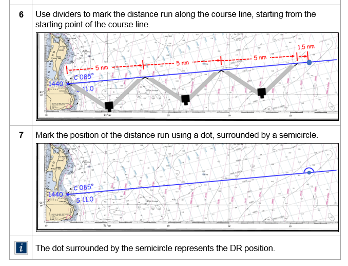
- Establish a DR Position
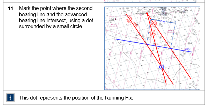
- Determine a Running fix
- Correcting for Current
- Determining Set and Drift of a Current
- Correcting for Leeway
- Establishing Danger Bearings
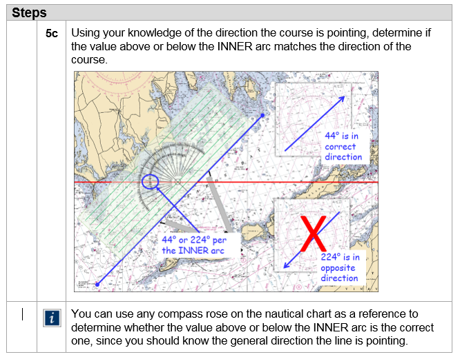
- Determine True course using Relative Bearings
- Read and understand Tide and Current Tables
The certification works as follows: first you take the 2-day classroom course. You leave the course with a Workbook with exercises, a pair of of dividers, an overlay plotter, a training nautical chart (1210 TR) and a very simple solar–powered calculator. You then need to schedule a time with the school to take the exam. The main thing you have to practice with, is 2 practice exams they provide.
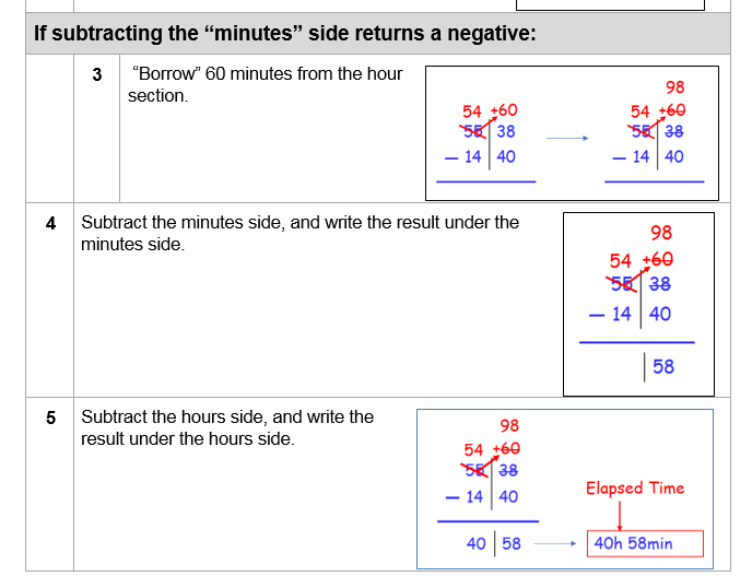
So for me, the 2-day course was only the beginning of my instruction on Coastal Navigation. The meat of the instruction for me, was after the course was over, when I made the decision to fully document each skill and technique in sufficient detail that I would always have a quick reference to fall back on. So for the next 4 weeks or so, I slowly went through each skill or technique, and documented each skill in a step-by-step procedure. All of this was being done on a computer, so that I would have a digital copy of the procedures. The basic method for each procedure was as follows: First, document the procedure using pen and paper. Next, transfer the procedure to an MS-Word document. Next came the challenging part, specifically for the techniques requiring writing on the nautical chart – to create clear visuals documenting each step in the paper plotting procedure.
What I found was that in the course of writing each skill in a step-by-step procedural format, is that I was forced to truly understand the skill thoroughly by the time that the documentation exercise was complete. That took a tremendous amount of time, but in the end it was definitely worth it. And now not only have I obtained the certification, but I also have a printed and bound permanent record of all which I have learned, documented in a way that I should always understand if I ever forget any skill and need to remember how to use it.
At this point the only key certification remaining for me to take under the ASA certification curriculum is the ASA 106 Advanced Coastal Cruising certification. This is where you learn to come into harbor at night, and other advanced skills allowing you to sail under any sea and weather conditions.
But at this point, more important than that course is for me to just get out there and get to sailing. Let’s get it!